Scientists from Cambridge University are joining a team of British researchers embarking on an ambitious mission to the Antarctic to learn more about recent ice loss.
Scientists from Cambridge University are joining a team of British researchers embarking on an ambitious mission to the Antarctic to learn more about recent ice loss.
The research project is important for understanding sea-level rise, a global phenomenon which has major implications for coastal cities and environments around the world.
Scientists from a range of British institutions are collaborating in a mission that aims to discover what is causing the recent rapid loss of ice from the Pine Island Glacier on the West Antarctic Ice Sheet and whether this depletion is likely to speed up or slow down over the coming decades and century. Details of the expedition were announced earlier today at the British Science Festival in Newcastle.
The research project – known as iSTAR – is important for understanding sea-level rise, a global phenomenon which has major implications for coastal cities and environments around the world. Funded by the Natural Environment Research Council, iSTAR brings together experts from different institutions in a range of related fields. Dr Andy Smith of the British Antarctic Survey (BAS) is the Science Programme Manager for the programme.
The Cambridge University scientists contributing to the project are Dr Marion Bougamont, Dr Poul Christoffersen and Professor Liz Morris. All three are glaciologists at the Scott Polar Research Institute (SPRI).
Dr Bougamont is geophysicist who uses computer models to study the subglacial processes that control the flow and mass balance of ice sheets. Dr Poul Christoffersen uses data collected in the field to study the interaction of ice sheets with climate and oceans. Both are part of ‘Dynamic ice’, an iSTAR group focusing specifically on Pine Island Glacier’s dynamic interaction with the ocean. Their contribution to the project will secure effective integration of field data in computer models needed in order to identify the cause of recent changes in ice flow. To acquire new data, members of this group will travel 600 miles across the ice sheet by tractor traverse in 2013-14, using ground-based radar and seismic technologies to map the bed beneath Pine Island Glacier.
Professor Liz Morris is known for her development of physics-based models for hydrological and hydrochemical processes involving snow and ice. She has worked in the European Alps, Canadian Rockies, Canadian Arctic, Greenland, Svalbard and Antarctica. Her contribution to the understanding of ice and snow has won her an OBE. Professor Morris is part of ‘Ice loss’, an iSTAR group focusing on ice sheet mass balance and its impact on sea-level rise. In this project, she will develop theoretical understanding of snow compaction, which is crucial for correct identification of Pine Island Glacier’s ongoing mass loss.
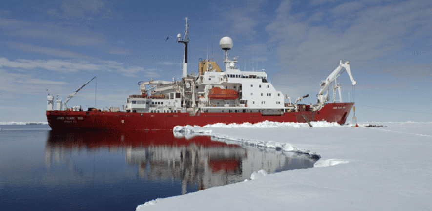
The iSTAR programme also includes ‘Ocean2ice’ and ‘Ocean under ice’, two groups focusing on polar oceanography. ‘Ocean2ice’ will deploy a fleet of ocean robots known as Seagliders from NERC’s research vessel RRS James Clark Ross, to take oceanographic measurements along the Antarctic continental shelf and thereby understand why warm seawater is increasingly flowing towards Pine Island Glacier. ‘Ocean under ice’ will send an autonomous robotic submarine into the cavity under the glacier’s floating ice shelf, in order to identify circulation and water masses there.
Seals will be enlisted to assist the scientists collect information about the ocean when its surface is covered by sea ice and inaccessible by ship. The animals will have tiny temporary sensors glued to their fur and will shed them during their seasonal moult. The information gathered will be sent back to scientists by satellite.
For more information see: www.istar.ac.uk/
For more information on this story, contact Alex Buxton, Office of Communications, University of Cambridge, amb206@admin.cam.ac.uk 01223 761673

This work is licensed under a Creative Commons Licence. If you use this content on your site please link back to this page.

, Polar Stratospheric Clouds., Credit: Cavan Images / Per-Andre Hoffmann via Getty Images")

