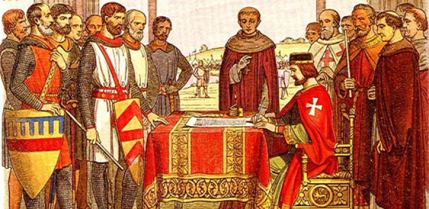
King John, that most restless of monarchs, is back in the spotlight as the 800th anniversary of the signing of Magna Carta approaches. For the first time, historical geographers have plotted John’s route for all 17 years of his reign to produce digital maps of his progress as he struggled to maintain his grip.
King John, that most restless of monarchs, is back in the spotlight as the 800th anniversary of the signing of Magna Carta approaches. For the first time, historical geographers have plotted John’s route for all 17 years of his reign to produce digital maps of his progress as he struggled to maintain his grip.
This summer, if you’re stuck in a traffic jam on the A171, think what it was like for John and his train of wagons
Max Satchell
John was the most peripatetic of all English monarchs. His 17 years on the throne are often described as a reign of crisis. In 1214 John lost his lands in France, earning him the name John Lackland. Beset by financial problems, and with his authority threatened by rebellious barons, John was seldom in residence at Windsor and Westminster – but spent much of his time on the move, raising taxes and holding courts, as he toured the country.
The first ever digital maps of John’s progress around his territories provide clues in visual format – and in certain sections show, almost yard by yard, the routes that King John is likely to have taken. Using Geographical Imaging Systems (GIS), researchers at Cambridge University have built on data from colleagues at the University of East Anglia (UEA) and University College London (UCL) to produce a compelling picture of the progresses of John and his successors, Henry III and Edward I.
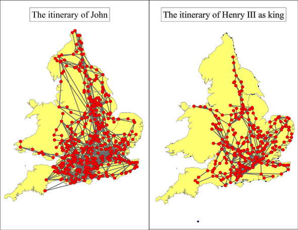
The maps reveal that John easily out-travelled those who came after him. In the six months leading up to Magna Carta, for example, he is recorded to have visited some 200 places and travelled well over 1,800 miles as he and his entourage zigzagged their way up and down England, navigating roads that were quagmires in winter.
Historical geographer Dr Max Satchell and PhD candidate Ellen Potter have applied mapping techniques that revolutionise the analytical capacity of data gathered by historians at UEA and UCL.
The Cambridge researchers have restructured thousands of dates and places in lists compiled from royal documents (for example, the signing of charters). By linking the restructured data to places digitally mapped using GIS, the progresses of the monarchs can be followed day-by-day, week-by-week, and year-by-year.
The GIS resource created by Satchell and Potter provides a valuable new tool. Unlike paper maps, the digital mapping enables comparisons to be made between the journeying of John, Henry III and Edward I, whose reigns together span the years 1199 to 1305. The digitised data reveals, for example, that John spent just 4% of his time at Windsor and Westminster while his successor Henry III spent 40% of his rule at these two palaces. Plotted on maps, the progresses of all three rulers can be seen at a glance.
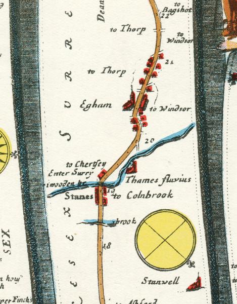
To plot in considerable detail the routes between places visited by the king, Satchell and Potter have drawn on a range of sources, notably Britannia, a volume published by John Ogilby in 1675. Often described as the ‘first road atlas’ of England and Wales, it consists of 100 plates of ‘strip maps’ compiled from information gathered by surveyors who travelled throughout England to measure and record some 7,000 miles of roads connecting major towns. Each strip map is a visualisation of the road taken between two points, complete with exquisitely drawn hills, rivers and landmarks.
Satchell has, for the first time, used GIS to recover the alignments of the main roads of 1675 from these strips and show with remarkable precision where they ran in the landscape. These main roads did not change much before the 18th century. This means that, where royal routes and Ogilby roads coincide, it is possible to see, almost yard by yard, where John and other kings travelled as they ascended and descended hills, crossed rivers, and stopped to obtain food, supplies and fresh horses.
“We can be pretty certain that the roads Ogilby and his team recorded were little changed from those that King John and other monarchs would have used. Even today the routes taken by sections of many roads have not changed for more than 800 years,” says Satchell.
“For example, when travelling from York to Durham, we know that John sometimes took a coastal route via Scarborough, Guisborough and Stockton-on-Tees. So too did Ogilby's surveyors, much of whose route is very similar to that of the modern A171 through the North York Moors National Park. So this summer, if you’re stuck in a traffic jam on the A171, think what it was like for John and his train of wagons.”
Although we know where John was in the week leading up to Magna Carta, clues to the roads he took have proved elusive. Between 5 and 8 June 1215, he was in residence at Winchester, formerly capital of England. By 9 June, John was in the market town of Odiham, some 20 miles north east of Winchester. Here, the king and his courtiers are likely to have stayed at Odiham Castle. From Odiham, John made his way to Windsor (some 24 miles north east) where the king was present from 10 June to 15 June.
“Undoubtedly, there was a direct road via Odiham which linked Winchester with Windsor and the navigable river Thames. Its existence is hinted by the itineraries of John and Henry III and also in later records, such as the shipment of lead carried by boat up the Thames, offloaded at Windsor and carted overland to repair the roof of Odiham castle in 1371, and wine carried from Southampton to Odiham in 1264. But, by the time the first large-scale maps of Hampshire were made in the 18th century, the road had virtually disappeared,” says Satchell.
”The final leg of John’s passage to Runnymede is solid enough. On 15 June, the king and his retinue journeyed the short distance from Windsor Castle to the fateful field. The barons for their part travelled from London on the main road to the south-west, a route clearly marked by Ogilby on plate 21 of his atlas. They crossed the Thames at Staines Bridge, marked as ‘wooden bridge’ by Ogilby, and turned off its causeway into Runnymede meadow from where they could see the towers of Windsor Castle.”
When on the move, royal baggage trains are thought to have travelled an average of 20 miles a day, moving at walking pace. Satchell and Potter’s mapping work confirms this picture. Distance was limited not just by the state of the roads and the weather but also by the weight of the wagons and carts. “The volume of stuff moved from point to point was quite literally staggering,” says Satchell.
“The royal baggage would have included a portable chapel for worship and a portable treasury which could carry as many as 500,000 silver pennies packed into barrels. In an era when John's misrule meant currency was in short supply, John’s retinue may have carried a significant proportion of the available coinage, a huge burden for horses to haul over unpaved roads.
Astride his own horse and accompanied by intimate companions, John would, of course, have been able to make greater speeds, travelling as much as 60 miles a day on a succession of the best animals. GIS analysis shows that John could make good speed even in winter across challenging terrain. In 1204 he journeyed from Malmesbury up and down the steep slopes of the Cotswolds to celebrate Christmas at Tewkesbury, riding more than 30 miles on a single winter’s day. The day after Christmas he made the return trip.
Travelling light was seldom an option. Wherever he went, John would have relied on a train of wooden wagons and carts, drawn by heavy horses, to convey the goods that he and his household required when at rest. In addition there would be packhorses, innumerable servants and an armed escort - a veritable cavalcade which must have provided a real spectacle as it crisscrossed the country. If travelling with his army, as he did in times of conflict, John’s baggage train could be over two miles in length.
John is remembered in school history books as the king “who lost his treasure in the wash”. Some 450 years before the draining of the fens in East Anglia, the wide estuary known as the Wash was marshy and treacherous. On 12 October 1216, the royal baggage train attempted to cross the waterway at low tide but got ensnared in the soft sand. Lives, vehicles, and much treasure were lost. John was safe: he took a different route from that taken by his train. But a week later he was dead.
The king’s body was carried in great ceremony some 140 miles from Newark to Worcester where he was buried in the city’s cathedral sometime in late October. Of this final journey, so much slower that many he made in life, nothing else is known. The flow of letters and charters from which John’s itinerary can be recovered ends with one last document – his will. Thereafter John becomes like his subjects whose innumerable toings and froings are lost forever.
Max Satchell is contributing to a major Cambridge University project to document the history of occupations. His specialism is in GIS and transport flows and infrastructure. Ellen Potter is a research assistant within the same group and will shortly start a PhD.
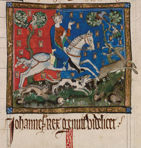
Inset images: The itineraries of John and Henry as king (Max Satchell); The route through Egham, from Ogilby's Britannia; Miniature of King John hunting, in a manuscript of the Liber legume antiquorum regum, C14, on display in Magna Carta: Law, Liberty, Legacy (British Library).

The text in this work is licensed under a Creative Commons Attribution 4.0 International License. For image use please see separate credits above.


