The city rises
Archaeologists have revealed an entire Roman city without any digging. Their approach could revolutionise the study of ancient settlements.

For the first time, a team of archaeologists from the Universities of Cambridge and Ghent, has succeeded in mapping a complete Roman city, Falerii Novi in Italy, using advanced ground penetrating radar (GPR). The technology has allowed them to reveal astonishing details while the city remains deep underground.

The archaeologists have discovered a bath complex, market, temple, a public monument unlike anything seen before, and even the city’s sprawling network of water pipes. By looking at different depths, they can now study how the town evolved over hundreds of years.
The research, published on 9 June 2020 in Antiquity, harnessed recent advances in GPR technology which make it possible to explore larger areas in higher resolution than ever before. This is likely to have major implications for the study of ancient cities because many cannot be excavated either because they are too large, or because they are trapped under modern structures.
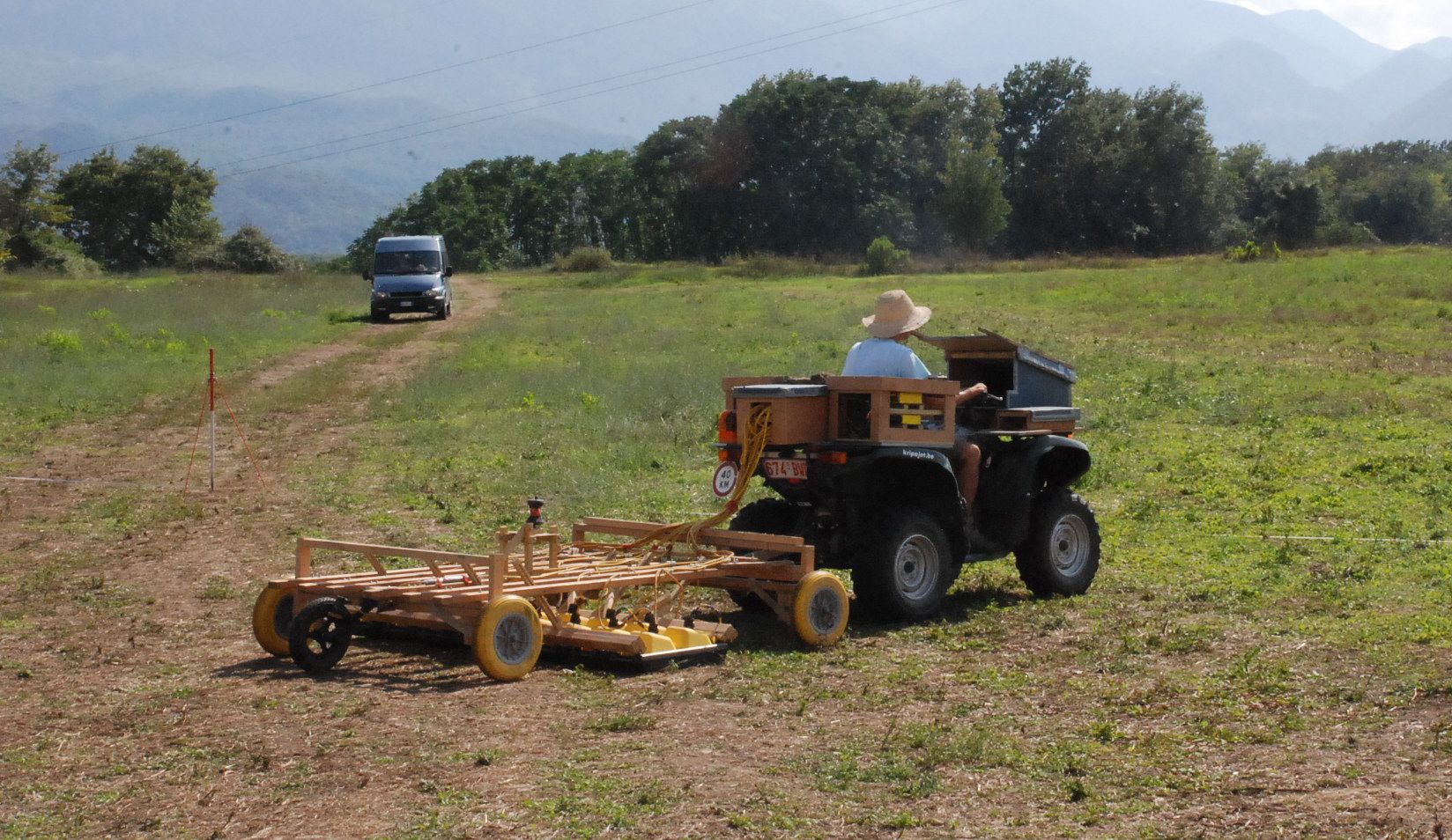
GPR works like regular radar, bouncing radio waves off objects and using the ‘echo’ to build up a picture at different depths. By towing their GPR instruments behind a quad bike, the archaeologists surveyed all 30.5 hectares within the city’s walls – Falerii Novi was just under half the size of Pompeii – taking a reading every 12.5cm.

Quad towing GPR array, with team member Dr Lieven Verdonck (Ghent University) on the Falerii Novi site. Image: Frank Vermeulen
Quad towing GPR array, with team member Dr Lieven Verdonck (Ghent University) on the Falerii Novi site. Image: Frank Vermeulen
Located 50 km north of Rome and first occupied in 241 BC, Falerii Novi survived into the medieval period (until around AD 700). The team’s GPR data can now start to reveal some of the physical changes experienced by the city in this time. They have already found evidence of stone robbing.

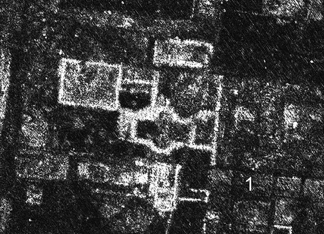
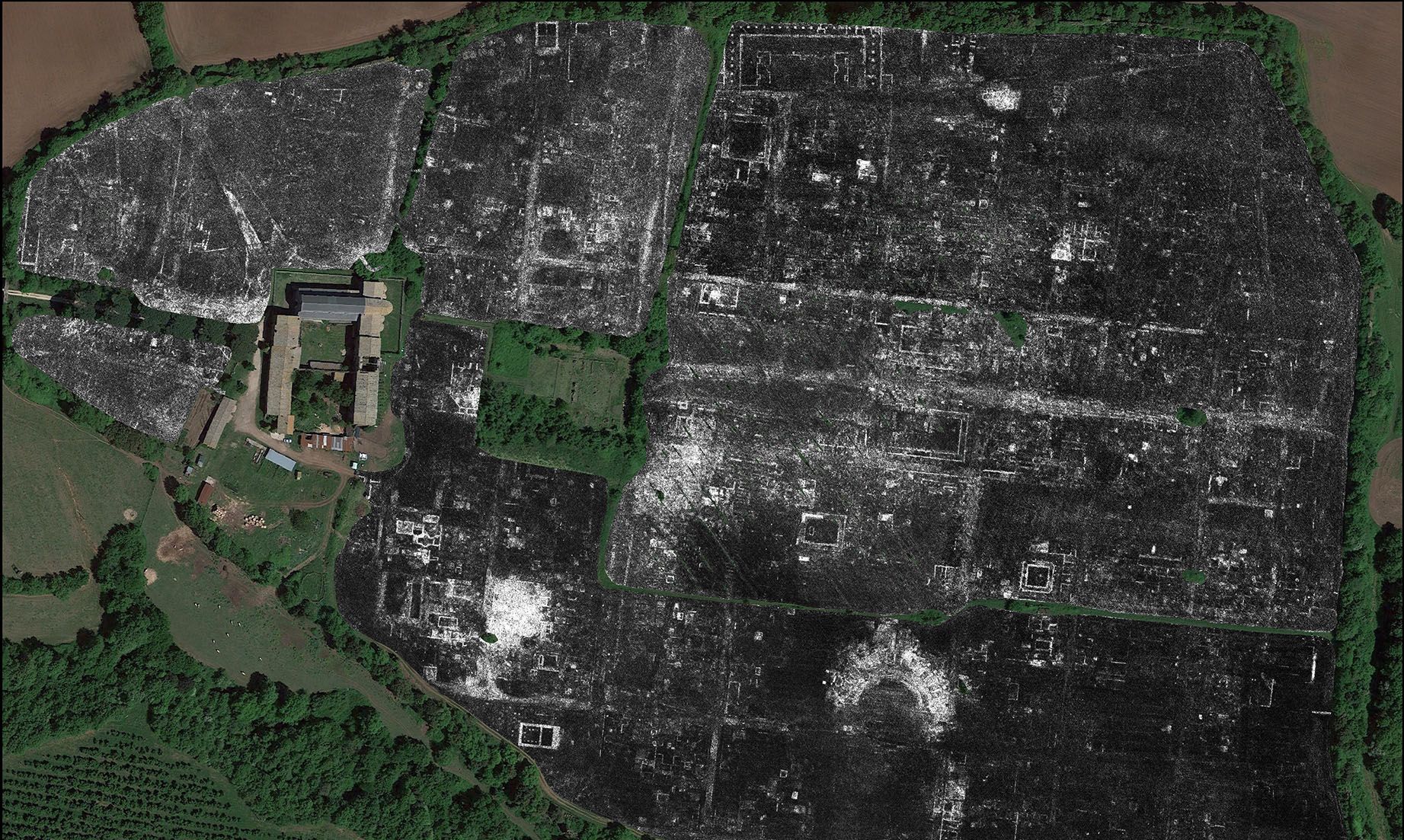
GPR time-slice in the case study area, at an estimated depth of 0.75–0.80m. (1) marks the removal of walls by stone robbing. Image: L. Verdonck
GPR time-slice in the case study area, at an estimated depth of 0.75–0.80m. (1) marks the removal of walls by stone robbing. Image: L. Verdonck
The study also challenges certain assumptions about Roman urban design, showing that Falerii Novi’s layout was less standardised than many other well-studied towns, like Pompeii. The temple, market building and bath complex discovered by the team are also more architecturally elaborate than would usually be expected in a small city.
Falerii Novi's temple
The bath complex
In a southern district, just within the city’s walls, GPR revealed a large rectangular building connected to a series of water pipes which lead to the aqueduct. Remarkably, these pipes can be traced across much of Falerii Novi, running beneath its insulae (city blocks), and not just along its streets, as might normally be expected. The team believes that this structure was an open-air natatio or pool, forming part of a substantial public bathing complex.

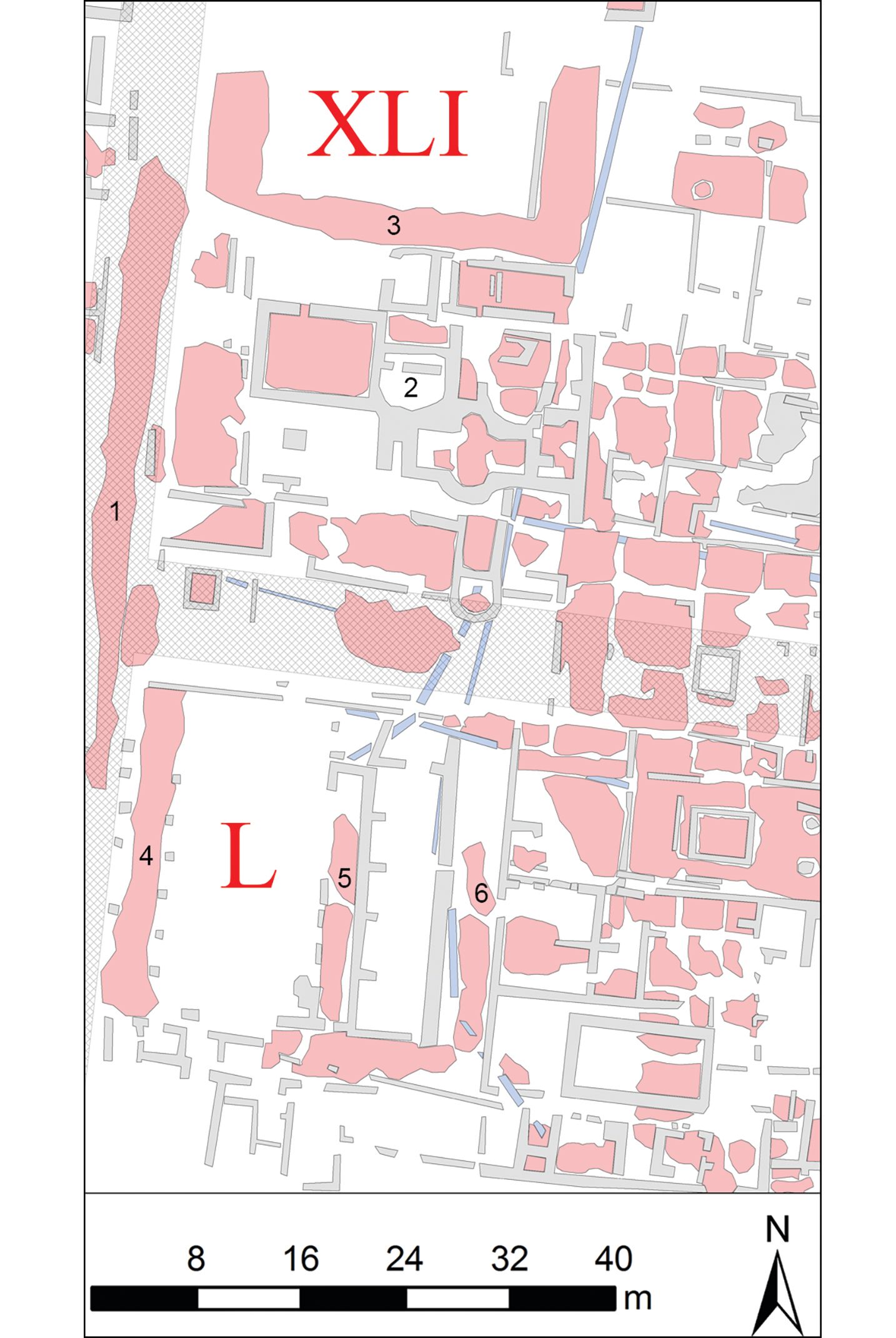
Illustration of Insulae XLI and L in Falerii Novi, showing walls in grey, surfaces in red and water pipes in light blue. (2) Bath house; (3) Possibly a portico surrounding an exercise area; (4) Passageway with columns on either side define western limits of a large cistern; (5) Passageway along centre of cistern articulated with buttresses along its east face; (6) Passageway along cistern's east side. Image: A. Launaro
Illustration of Insulae XLI and L in Falerii Novi, showing walls in grey, surfaces in red and water pipes in light blue. (2) Bath house; (3) Possibly a portico surrounding an exercise area; (4) Passageway with columns on either side define western limits of a large cistern; (5) Passageway along centre of cistern articulated with buttresses along its east face; (6) Passageway along cistern's east side. Image: A. Launaro
Even more unexpectedly, near the city’s north gate, the team identified a pair of large structures facing each other within a porticus duplex (a covered passageway with central row of columns). They know of no direct parallel but believe these were part of an impressive public monument, and contributed to an intriguing sacred landscape on the city’s edge.

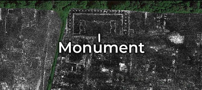
The porticus duplex and public monument to the east of Falerii Novi's north gate, shown on a GPR time-slice, at an estimated depth of 0.80–0.85m. The white dots mark the central row of columns of the covered passageway approximately 90 × 40m. Within, a pair of structures facing each other (each with a central niche) acted as a public monument. Image: L. Verdonck
The porticus duplex and public monument to the east of Falerii Novi's north gate, shown on a GPR time-slice, at an estimated depth of 0.80–0.85m. The white dots mark the central row of columns of the covered passageway approximately 90 × 40m. Within, a pair of structures facing each other (each with a central niche) acted as a public monument. Image: L. Verdonck
Corresponding author, Professor Martin Millett from Cambridge’s Faculty of Classics, said:
“The astonishing level of detail which we have achieved at Falerii Novi, and the surprising features that GPR has revealed, suggest that this type of survey could transform the way archaeologists investigate urban sites, as total entities.”
Millett and his colleagues have already used GPR to survey Interamna Lirenas in Italy, and on a lesser scale, Alborough in North Yorkshire, but they now hope to see it deployed on far bigger sites.
“It is exciting and now realistic to imagine GPR being used to survey a major city such as Miletus in Turkey, Nicopolis in Greece or Cyrene in Libya. We still have so much to learn about Roman urban life and this technology should open up unprecedented opportunities for decades to come.”
The sheer wealth of data produced by such high-resolution mapping does, however, pose significant challenges. Traditional methods of manual data analysis are too time consuming, requiring around 20 hours to fully document a single hectare. It will be some time before the researchers finish examining Falerii Novi but to speed the process up they are developing new automated techniques.
Falerii Novi is well documented in the historical record, is not covered by modern buildings and has been the subject of decades of analysis using other non-invasive techniques, such as magnetometry, but GPR has now revealed a far more complete picture.
Reference: L. Verdonck, A. Launaro, F. Vermeulen & M. Millett, ‘Ground-penetrating radar survey at Falerii Novi: a new approach to the study of Roman cities’, Antiquity (9 June 2020)
The project was funded by the AHRC. Lieven Verdonck, from Ghent University, was employed on a post-doctoral fellowship from the Fund for Scientific Research—Flanders (FWO).The team is also grateful to the Soprintendenza Archeologia, Belle Arti e Paesaggio per l’Area Metropolitana di Roma, la Provincia di Viterbo e l’Etruria Meridionale.
Further details here.