Plotting a land grab
A newly decoded map reveals that the famous American explorer William Clark planned the theft of 10.5 million acres of Indigenous land


A once-in-a-lifetime archival discovery reveals that a rare map hiding behind a false identity in Washington D.C. was the work of William Clark, the once revered but now increasingly controversial American explorer (Lewis and Clark Expedition), Indian agent and territorial governor.
The sketch, newly reattributed, re-dated and painstakingly decoded by University of Cambridge historian Dr Robert Lee exposes Clark’s scheming at the heart of a pivotal moment in 19th-century American history. This event robbed Indigenous Americans of land the size of Switzerland in what is now Missouri, and fuelled the expansion of slavery.
Dr Robert Lee was scrolling through yet another microfilm from the National Archives and Records Administration in Washington D.C. when an intriguing map – filed in the secretary of war’s correspondence archive under the authorship of Captain Eli B. Clemson – stopped him in his tracks.
Lee quickly noticed that the basic geography of the Osage treaty of 1808 depicted by the map clashed with accepted wisdom about that major cession of land.

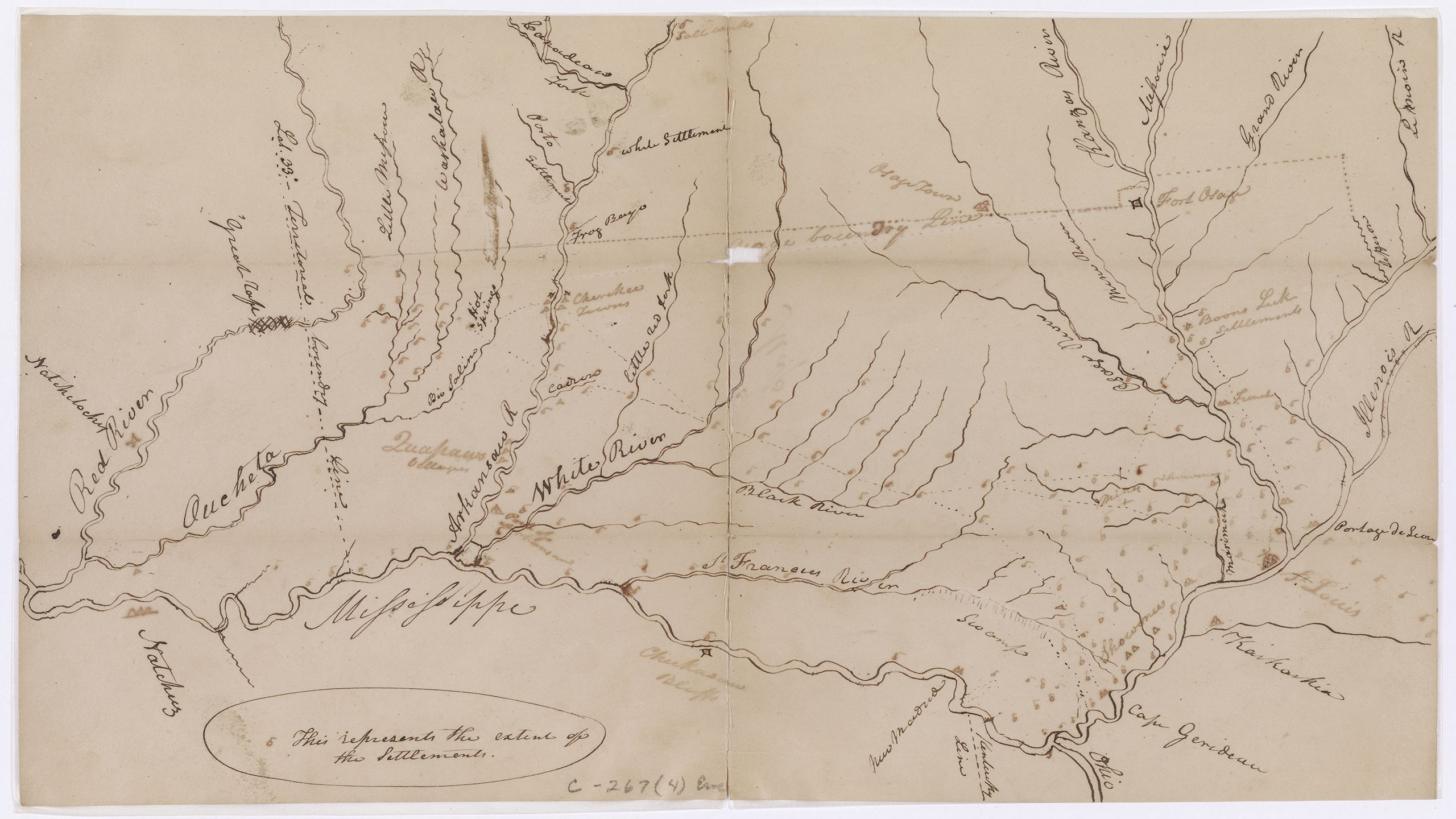
William Clark, Map of Extent of Settlement in Mississippi Valley (1816). National Archives and Records Administration, Washington, D.C.
William Clark, Map of Extent of Settlement in Mississippi Valley (1816). National Archives and Records Administration, Washington, D.C.
In a new study, published today in the journal, William and Mary Quarterly, Lee argues that this map was actually drawn by William Clark, then governor of the Missouri Territory, and shows how he grafted 10.5 million acres of Sauk, Meskwaki, and Iowa territory onto the United States after the War of 1812 by reinterpreting the 1808 Osage treaty.
This little-known land seizure violated the Treaty of Ghent with Great Britain, triggered a stampede of slaveholding emigrants, and reshaped Missouri’s political boundaries.

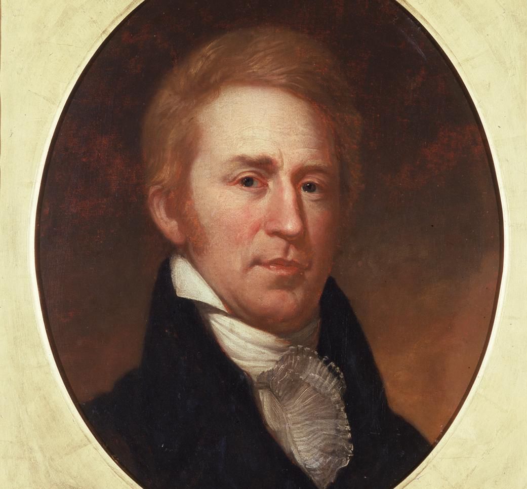
Charles Willson Peale, Portrait of William Clark (oil on paper mounted on canvas, 1807). Independence National Historic Park Collection, Philadelphia, PA.
Charles Willson Peale, Portrait of William Clark (oil on paper mounted on canvas, 1807). Independence National Historic Park Collection, Philadelphia, PA.


Chester Harding, William Clark as Governor of the Territory of Missouri (oil on canvas, c. 1820). St. Louis Mercantile Library Art Museum
Chester Harding, William Clark as Governor of the Territory of Missouri (oil on canvas, c. 1820). St. Louis Mercantile Library Art Museum
Dr Lee, an assistant professor of history and Fellow of Selwyn College, Cambridge, says:
“This astonishing map shows how William Clark leveraged the U.S.–Indian treaty system to promote settler supremacy in the United States at a time when he’s been praised for trying to protect Indigenous land from squatters. Now we can see just how scheming and disingenuous he really was.”
The unsigned, undated map sketched in ink and pencil contains about fifty named features, roughly half of them rivers, the rest towns and settlements, mines, salt licks, springs, and boundary lines. There are also more than 150 unnamed features, most unidentified settlements along nondescript streams.
Identifying Clark
A handful of the landmarks prove that Captain Clemson cannot have drawn the map – Lee believes this misattribution was made in the 19th century – and that it can only be a settlement map William Clark composed in 1816, which historian Clarence Edwin Carter declared missing in 1951.
The map’s style, spelling and symbols all point to Clark. But the most revealing feature, pictured below, is a line between the Arkansas and Red Rivers, which Clark described in the 1816 letter that accompanied the map before the two got separated.

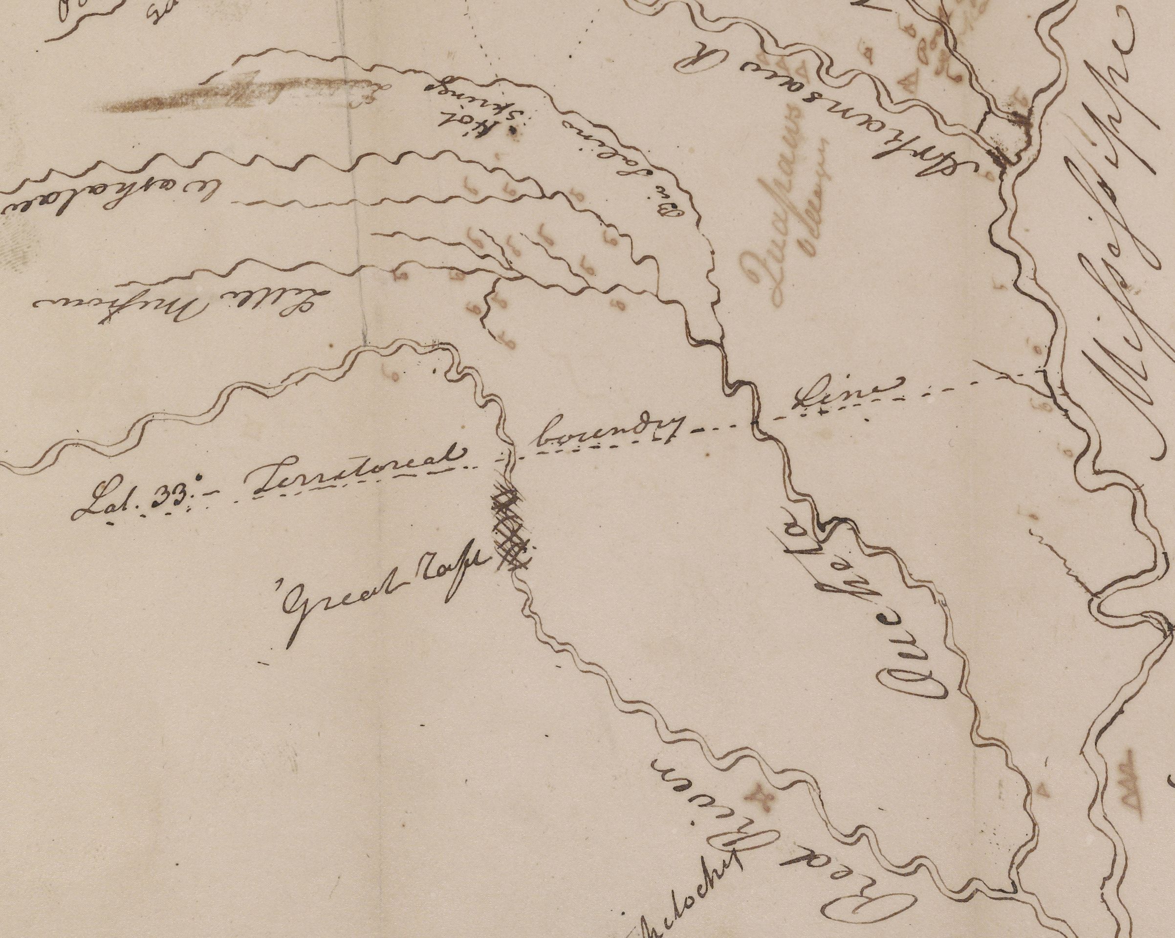
Caught in the act
With the real source identified, Dr Lee was able to decode the surprising significance of another unlabelled, dotted line on the map, pictured below: Clark personally orchestrated a little-known scheme to steal the upper half of what is today the state of Missouri from its indigenous owners.

Lee says: “This stray line looks like the cartographic equivalent of a Freudian slip. It’s the closest thing we have to an admission in Clark’s own hand that he dispossessed the Sauks, Meskwakis, and Iowas of a huge tract of land to hasten settler supremacy in Missouri.
“Clark didn’t discuss this plan in his 1816 letter and it remains largely unknown today despite playing an integral part in Missouri’s colonization.”
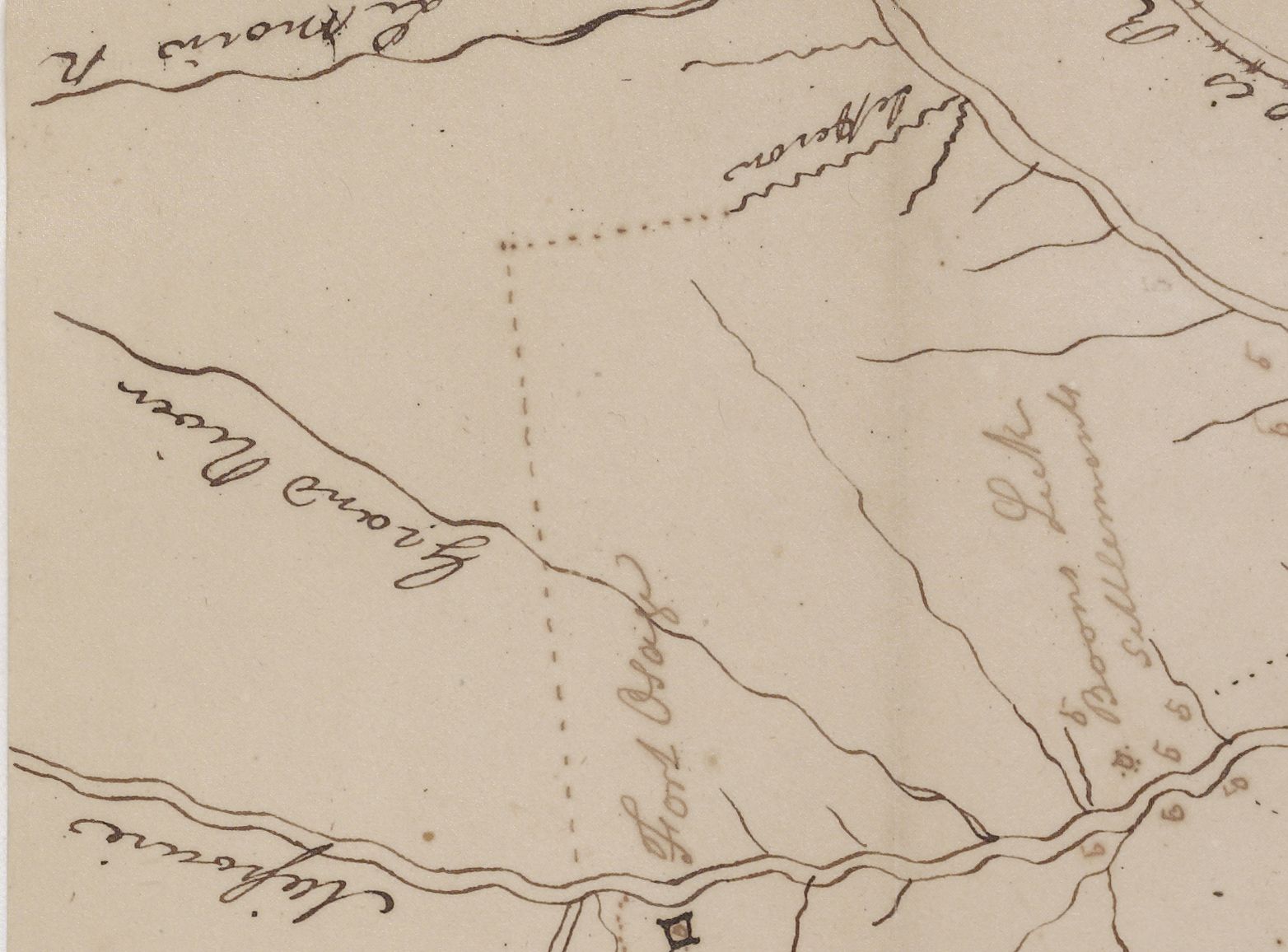
In 1815, after failing to purchase land north of the Missouri River from the Sauks, Meskwakis and Iowas, Clark withdrew recognition of their possession and asserted by proclamation that the United States had already bought this region from the Osages by treaty in 1808.
By taking it upon himself to redraw an Indian treaty line right after the War of 1812 — that unlabelled line on the map — Clark secured an invasive squatter settlement, Boon’s Lick, and added millions of acres to the U.S. public domain in violation of the Treaty of Ghent. In doing so, he deliberately circumvented official orders to restore prewar Indian boundaries.

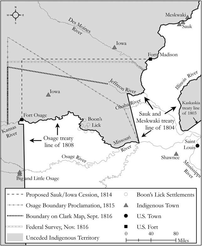
Indian boundaries projected around Boon’s Lick between the Osage Treaty of 1808 and the federal survey of that line in 1816, including Clark’s proposed Sauk and Iowa line of 1814, his Osage proclamation line of 1815, and its representation on his 1816 map enclosure. Drawn by Robert Lee
Indian boundaries projected around Boon’s Lick between the Osage Treaty of 1808 and the federal survey of that line in 1816, including Clark’s proposed Sauk and Iowa line of 1814, his Osage proclamation line of 1815, and its representation on his 1816 map enclosure. Drawn by Robert Lee


Boonville, Missouri in 2015. In the 19th century, Boonville was part of Boon's Lick, a sprawling settlement approximately 30 x 50 miles. The heart of Boon's Lick was north of the Missouri River, Boonville is south of the river. Image: Robert Stinnet via Flikr under a CC license
Boonville, Missouri in 2015. In the 19th century, Boonville was part of Boon's Lick, a sprawling settlement approximately 30 x 50 miles. The heart of Boon's Lick was north of the Missouri River, Boonville is south of the river. Image: Robert Stinnet via Flikr under a CC license
“A naïve interpretation might say Clark found a huge loophole in the Treaty of Ghent. A realistic one would say he broke it to seize a landmass triple the size of Connecticut.”
Clark’s legacy
Clark’s land grab worked by denying that his post-war interpretation of the Osage treaty was new. He carefully maintained the fiction that he had clarified an old boundary, not manufactured one.
Lee says: “This plan worked so well that historians have tended to either believe him or overlooked the incident entirely.”
Thousands of emigrants, many of them slaveholders, flocked in to take advantage and the settler population on the stolen lands skyrocketed. This influx drove Missouri toward statehood and drowned out the protests of the Sauks, Meskwakis, and Iowas.
Clark eventually cleared their title to the land on the cheap – treaties made in 1824 paid out less than half a cent an acre for the territory, which was already selling for 4 to 12 dollars per acre. For the Sauks, Meskwakis and Iowas, the land grab contributed to generations of hardship.


George Catlin, The White Cloud, Head Chief of the Iowas (oil on canvas, 1844-45). National Gallery of Art, Washington D.C. (Paul Mellon Collection)
George Catlin, The White Cloud, Head Chief of the Iowas (oil on canvas, 1844-45). National Gallery of Art, Washington D.C. (Paul Mellon Collection)

![George Catlin, Kee-o-kúk, The Watchful Fox, Chief of the [Sauk] Tribe, (Oil on canvas, 1835). Smithsonian American Art Museum (Gift of Mrs. Joseph Harrison, Jr., 1985.66.1)](https://www.cam.ac.uk/sites/www.cam.ac.uk/files/shorthand/229651/Pel6p6dSC4/assets/RBfY1VRPwd/sauk-image-_george-catlin-kee-o-kuk-the-watchful-fox-chief-of-the-tribe-1835-oil-on-canvas-smithsonian-american-art-museum-gift-of-mrs-joseph-harrison-jr-1985-66-1-2454x3000.jpeg)
George Catlin, Kee-o-kúk, The Watchful Fox, Chief of the [Sauk] Tribe, (Oil on canvas, 1835). Smithsonian American Art Museum (Gift of Mrs. Joseph Harrison, Jr., 1985.66.1)
George Catlin, Kee-o-kúk, The Watchful Fox, Chief of the [Sauk] Tribe, (Oil on canvas, 1835). Smithsonian American Art Museum (Gift of Mrs. Joseph Harrison, Jr., 1985.66.1)
Over the course of his career, Clark is now thought to have links to the taking of 419 million acres of indigenous land, well over a third of the dominion claimed by the United States at the time of his death in 1838.
Nevertheless, questions linger about whether he was a “sentimental imperialist,” a hard-nosed proponent “of white settler imperialism and ethnic cleansing,” or something in between.
That a publicly accessible map by William Clark has gone unnoticed for so long is extraordinary. Inspired by the fame of the Corps of Discovery – the core of the Lewis and Clark Expedition of 1804-6 – researchers have avidly sought out all things Clark-related.
Since the late nineteenth century, Clark manuscripts have turned up in a trash heap in Kansas, an apartment in New York City, a basement in Washington, D.C., and attics in Minnesota and Kentucky. But the last original maps surfaced among private papers in Saint Paul in 1953.
Reference
R. Lee, ‘“A Better View of the Country”: A Missouri Settlement Map by William Clark’, William and Mary Quarterly (2022). DOI: 10.5309/willmaryquar.79.1.0000
In 2021, Robert Lee won a George Polk Award, one of the most prestigious in journalism, for his investigation into how the United States funded land-grant universities with expropriated Indigenous land.
Published 7th February 2022
