Using satellite imagery, researchers have developed the first systematic approach for tracking the recovery of regions stricken by natural disaster.
Using satellite imagery, researchers have developed the first systematic approach for tracking the recovery of regions stricken by natural disaster.
The hope is that this approach will help to ease the enormous burden that disasters place on communities worldwide by helping to speed up decision making and coordinate best practice in the lengthy process of recovery.
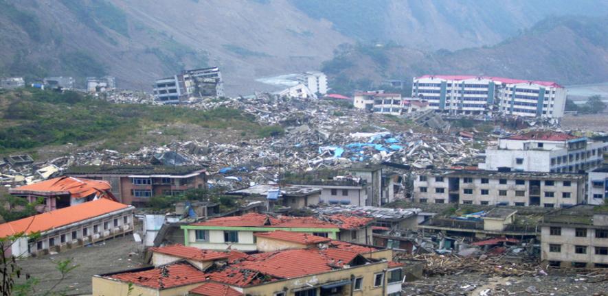
Earthquakes, tsunamis, hurricanes, floods and volcanic eruptions – natural hazards such as these are inevitable and at times disastrous, causing horrific loss of life and widespread damage. Although these events can affect regions all over the world, the likelihood of a devastating impact is far greater for developing countries, sometimes wiping out decades of development work in a few seconds. According to figures from the World Bank, developing countries experience not only a higher number of natural disasters (in some years, as many as six times more) but also 20 times greater direct and indirect losses compared with industrialised countries.
When disaster strikes, the relief phase in the immediate aftermath is focused on life-saving tasks, finding survivors and providing food, water and sanitation. And then begins the process of recovery – a long, costly and complex period in which amenities, schools and livelihoods need to be rebuilt and, for those affected by the disaster, some sense of a return to normality.
It is to this process of post-disaster recovery that researchers in Cambridge have been making a significant contribution – both by providing immediate engineering and architectural expertise at the sites of disaster (see panel) and by developing the first systematic approach to monitoring and evaluating how the recovery process is progressing.
Need for knowledge
‘Surprisingly, considering the billions that are spent in aid, there is currently no integrated approach for assessing long-term recovery,’ explains Daniel Brown who, with Dr Torwong Chenvidykarn and Dr Keiko Saito in the Department of Architecture, has been responsible for spearheading a new approach to the complex problem of post-disaster monitoring and evaluation.
‘The various stakeholders – government departments, NGOs, donors and executing agencies – currently use an assortment of data collection methods such as surveys, interviews and direct observations,’ he continues. ‘These methods can be time-consuming and prone to inconsistencies, and might be taking place in situations that are confusing and dangerous.’ In some extreme cases, no monitoring and evaluation data can be collected at all, either because access to the country has been denied by its government or security is a critical issue.
Yet, evaluations are vitally important, says Dr Saito: ‘Lessons can be learned from how quickly regions do or don’t recover. Evaluations also assist in ongoing work on the ground, and provide long-term accountability to donors.’
The recovery project
Thanks to recent technological advances, the Cambridge researchers have been able to look in a new way at assessing what is happening on the ground: in fact from high above the Earth, using very high-resolution optical satellite imagery.
Satellites are now in widespread use for capturing virtually instantaneous images from space of disaster areas. However, Daniel Brown and colleagues have taken the information these images provide a step further. Working in association with Cambridge Architectural Research (a spin-out from the Department of Architecture) and ImageCat (an R&D company providing advanced technologies for risk and disaster management), and with funding from the Engineering and Physical Sciences Research Council, the team has developed a means of extracting information from the images that is at once incredibly detailed and yet gives a region-wide evaluation of the situation.
At the heart of the approach is a set of 12 ‘performance indicators’ that map aspects of the recovery process, including population movements and the construction of dwellings, transportation and road accessibility, livelihoods and crop damage, healthcare and schooling, and facilities such as power, water and sanitation. The indicators were designed following discussion with affected communities, members of the international aid community, national recovery agencies and local NGOs.
Features related to each of the performance indicators are tracked in satellite images taken before, immediately after the disaster and at months and years thereafter, using manual mapping methods and semi-automated techniques such as object-based image analysis. Not only does this provide an independent snapshot of recovery but, significantly, it also maps its speed and quality, providing valuable feedback to stakeholders.
Monitoring real disasters
The team focused on two very different disasters: Baan Nam Khem, a fishing village on the west coast of Thailand that was severely hit by the 2004 tsunami, and Muzaffarabad, Pakistan, which was struck by the Kashmir earthquake of 2005.
With a remarkable level of resolution, capable of zooming in to see objects 60 cm in width, the researchers were able to infer the speed of recovery of the fishing industry in Thailand by analysing, for instance, pier length and the presence of trawlers in the satellite images. Agriculture in Pakistan was monitored through crop cycle patterns. Road rehabilitation, debris removal, the building and dismantling of emergency camps, the appearance of temples, even the distance between new dwellings and the market, all helped piece together elements of the recovery jigsaw. And in each case study, what was inferred from the satellite image was verified against narratives from the ground: the opinions of affected citizens, those directly involved in the recovery and the government ministries.
Any disaster, anywhere
The technique is being updated as new technology becomes available – the most recent being the use of high-resolution oblique aerial photographs called pictometry (see below). Significantly, the Recovery Project has been developed for use in any disaster in any region and can produce an enormous array of different types of data on the recovery process. ‘The next stage of the project,‘ Dr Chenvidykarn explains, ‘will be to work even closer with aid agencies and government departments to comprehend which particular aspects of the data they would find most useful to integrate into their usual working practices.’
Ultimately, the hope is that this approach will help to ease the enormous burden that disasters place on communities worldwide by helping to speed up decision making and coordinate best practice in the lengthy process of recovery.
For more information, please contact Daniel Brown (dmb56@cam.ac.uk), Dr Torwong Chenvidykarn (tc233@cam.ac.uk) and Dr Keiko Saito (ks269@cam.ac.uk).
Earthquake Engineering Field Investigation
For over 25 years, Cambridge researchers have been involved in reconnaissance missions following major earthquakes worldwide.
After the initial emergency relief operation is under way, one of the most important tasks is to assess the performance of structures and foundations under the ground where shaking occurred. This is the objective of the Earthquake Engineering Field Investigation Team (EEFIT) – a group of engineers and architects from British universities and industry who mobilise following disasters like the devastating Haiti earthquake of 12 January 2010.
Co-founded by Robin Spence, Cambridge’s Emeritus Professor of Architectural Engineering, the EEFIT team currently includes Dr Keiko Saito and Dr Gopal Madabhushi from the Departments of Architecture and Engineering, respectively, both of whom took part in the reconnaissance mission to Haiti.
Dr Saito’s focus is to examine damage using high-resolution satellite images and aerial images to assist in the process of post-disaster needs assessment: ‘In Haiti, we used high-resolution oblique aerial photographs called pictometry, which was available for the first time following an earthquake. Unlike vertical aerial images, it captures aerial views of the façade of buildings. This proved ideal for assessing damage and the results contributed to the estimation of the cost of reconstruction by the World Bank.’
Dr Madabhushi leads the Earthquake Geotechnical Engineering group at the Department of Engineering’s Schofield Centre, home to a centrifuge 10 metres in diameter that simulates the effects of earthquakes. Much of his research looks at how building foundations perform under seismic stress, particularly when degradation of the soil effectively causes it to act as a liquid. ‘If this happens, buildings can sink into the ground, as in the harbour region of Port-au-Prince, Haiti,’ he says. ‘One way of reducing the problem is to super-compact the soil around buildings and bridges. We’ve been investigating how this can be achieved economically in earthquake-vulnerable regions that have few resources.’
For more information, please contact Dr Keiko Saito (ks269@cam.ac.uk) and Dr Gopal Madabhushi(mspg1@cam.ac.uk).

This work is licensed under a Creative Commons Licence. If you use this content on your site please link back to this page.


